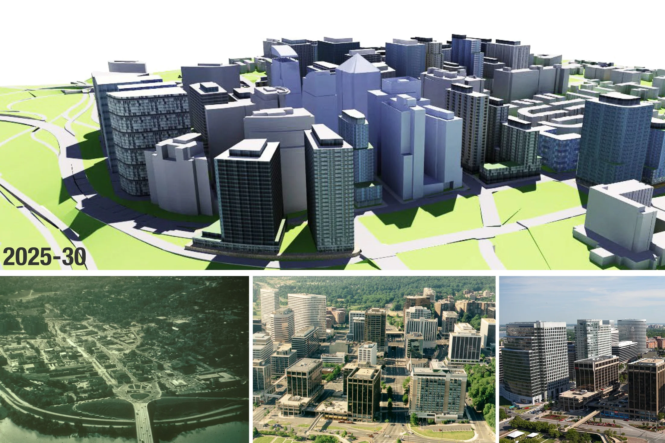
REALIZE ROSSLYN PLAN Arlington, VA
A two-year community planning effort involving a diverse group of residents, property owners, and business representatives, Realize Rosslyn culminated in a comprehensive vision and plan to transform this economic hub of the County into a more walkable, dynamic, live-work-shop-play urban center and vibrant gateway to Arlington
Completed at: Goody Clancy
Client: Arlington County, VA
Project Roles: Site capacity studies, FAR & three dimension massing studies, community workshop facilitation, before-after visualizations
DURHAM.ID MASTER PLAN, Durham, NC
Durham.ID Master Plan is an integrated planning and urban design framework that sets a new precedent for implementing state-of-the-art innovation districts in the mid-size city of Durham, North Carolina.
Unlike single-use innovation clusters in suburban greenfield sites or larger-scale redevelopment efforts in post-industrial districts, Durham.ID is designed to promote innovation with normative commercial and laboratory building types, while furthering mixed-use neighborhood creation, infill development, historic preservation and adaptive reuse.
Completed at: CBT Architects, Boston, MA
Client: Longfellow Development Partners
Project Roles: Project management, zoning and regulatory studies, building capacity and parking studies, development of design guidelines, master planning report authorship
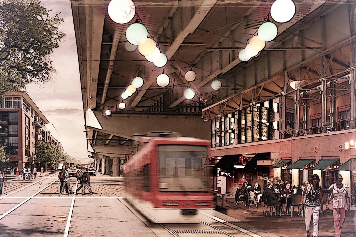
In collaboration with transportation planners, Goody Clancy team worked with communities and public agencies to rethink the Clairborne Corridor in New Orleans, developing plans that are both transformative and pragmatic.
Replacing failing highway viaducts and roadways that have a blighting influence on their communities with new infrastructure that is better integrated with the city, supporting economic development, transportation, and community needs
Transforming arterial corridors into walkable, mixed-use districts that reconnect communities and foster new investment
Reinventing urban main streets that have become overwhelmed by traffic, creating plans that make them centers of community life—attracting new investment and incorporating transportation concepts that balance the needs of pedestrians, bicyclists, and drivers
Completed at: Goody Clancy,
Project Role: Streetscape design, phasing and visualization in close collaboration with transportation planners
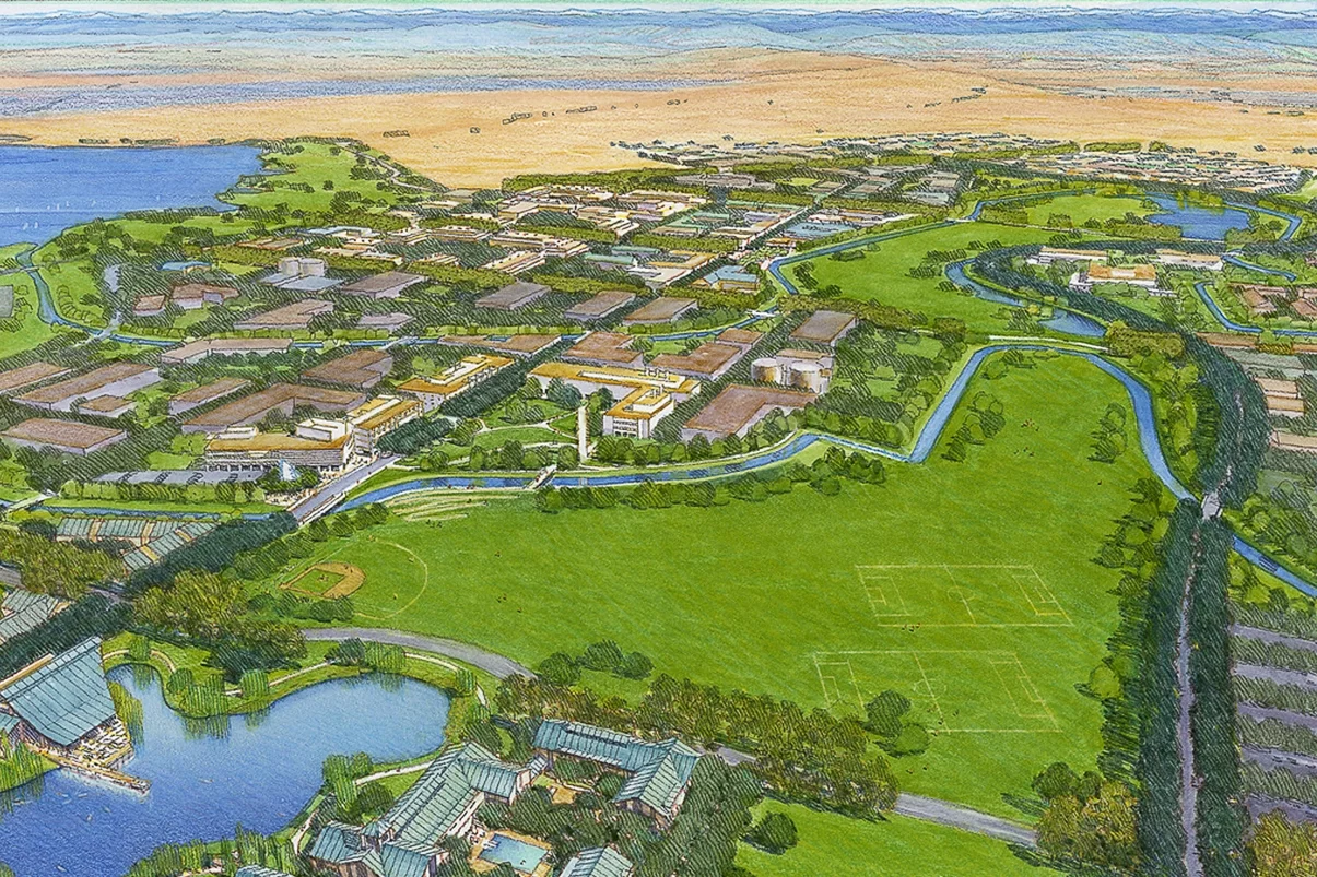
UNIVERSITY OF CALIFORNIA AT MERCED MASTER PLAN
The University of California at Merced was the first major university campus in the United States to open in the 21st century. UC Merced had the opportunity to further define the role and form of the university at a time of accelerated change in technology and information access.
Four general themes guided the physical development of UC Merced: technology, outreach, sustainability, and model for growth. The 2,000-acre campus was planned for an eventual 25,000 students. It is composed of three primary land-use elements: the Main Campus, the Campus Reserve, and the Campus Natural Preserve. Each has an important role in the three key missions of the university: teaching, research, and public service.
The campus sets an example for urban growth in the San Joaquin Valley, showing how increases in population can be accommodated while preserving the agricultural and environmental basis of its economy and ecosystem. Every aspect of its construction and operation achieved a high level of resource conservation, including materials, energy use, and sustainability.
Completed at: SOM San Francisco
Project Roles: Site planning studies, design studies for environmental remediation, urban design concept development, master planning report production
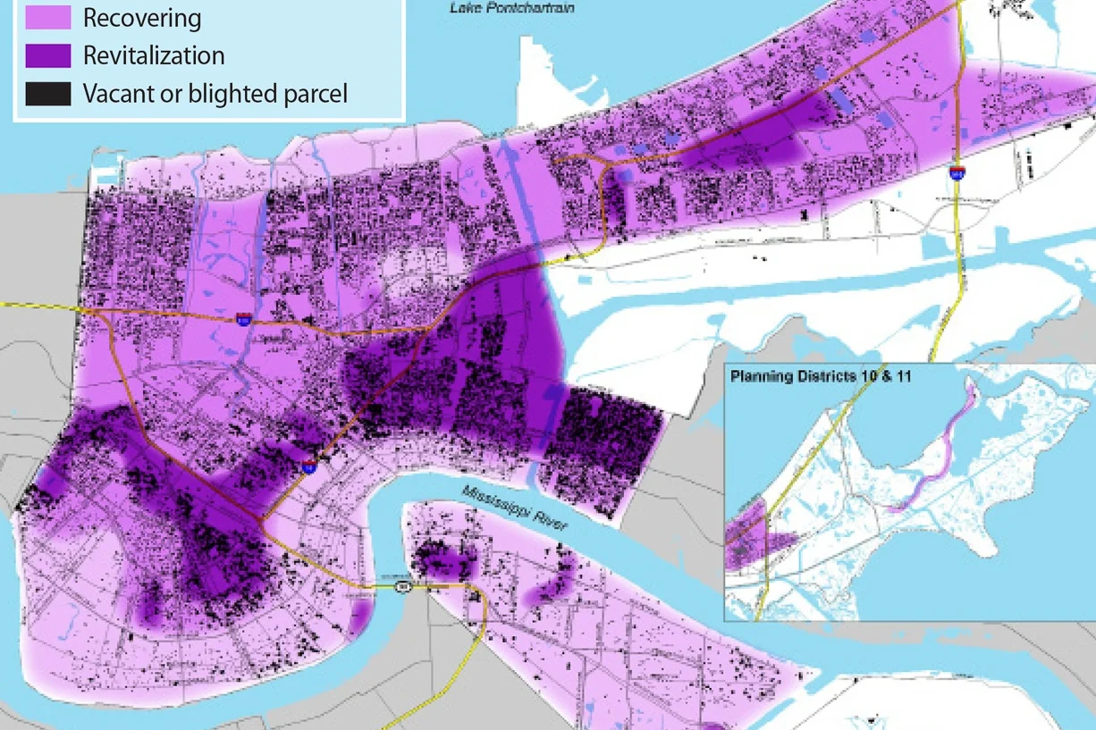
Three years after Hurricane Katrina, the New Orleans City Planning Commission chose a team led by Goody Clancy to prepare a citywide master plan and a new comprehensive zoning ordinance. While the plan reflects recovery planning in which residents had invested considerable effort, it goes beyond recovery to lay out a vision of livability, opportunity, and sustainability over 20 years for the city’s physical development and its social, economic, and environmental future. More than 5,000 people participated in the community participation process.
Completed at Goody Clancy Associates
Specific Responsibilities: Neighborhood Design Concepts, Photomontage & future scenario visualizations, zoning diagrams, and design guidelines
AGA KHAN UNIVERSITY VILLAGE LANDUSE PLAN, Karachi, Pakistan
The Aga Khan University Village Land Use Plan creates a 650-acre academic and research community complementing the 450-acre campus and neighboring educational institutions with residential neighborhoods, services, and campus amenities.
The plan addresses access, security, land use mix, and phased development while building upon the region's city building history and cultural values. One of the critical challenges was to ensure the development on the hot, arid site was environmentally sustainable.
It was also important to root the village in its unique socio-economic contexts to establish a sense of place, while cultivating an international community fostering rich academic and cultural discovery on a site with virtually no development or context today.
Completed at: Goody Clancy
Project Role: Research and study of building types and public open spaces in historic Muslim cities, concept and plan development, detailed study, and development of housing prototypes for a range of living situations.
Awards: Society of College and University Planning Merit Award 2010
BEACON YARDS DESIGN CHARETTE / BOSTON SOCIETY OF ARCHITECTS
Keeping in mind the theme of ‘living with infrastructure,’ the scheme proposes an elevated linear public space along the realigned Massachusetts Turnpike and Rail Corridor.
This raised space would become an important link between Lower Allston, the Charles River, the newly proposed West Station, Boston University, and Magazine Beach across the river in Cambridge. This robust network would be the early action investment in Beacon Yards resulting in direct pedestrian and bike connections both between the Lower Allston neighborhood and the Charles River pedestrian and bicycle path, and between Commonwealth Avenue and Beacon Yards along the north-south axis.
In addition to serving as the primary place-making strategy for the proposal, the open space network adds value to the adjacent real estate parcels. Its orientation and organization provide value on all sides and great views toward the Boston skyline.
Completed at: CBT Architects
Specific contributions: Concept development, design visualization, team coordination
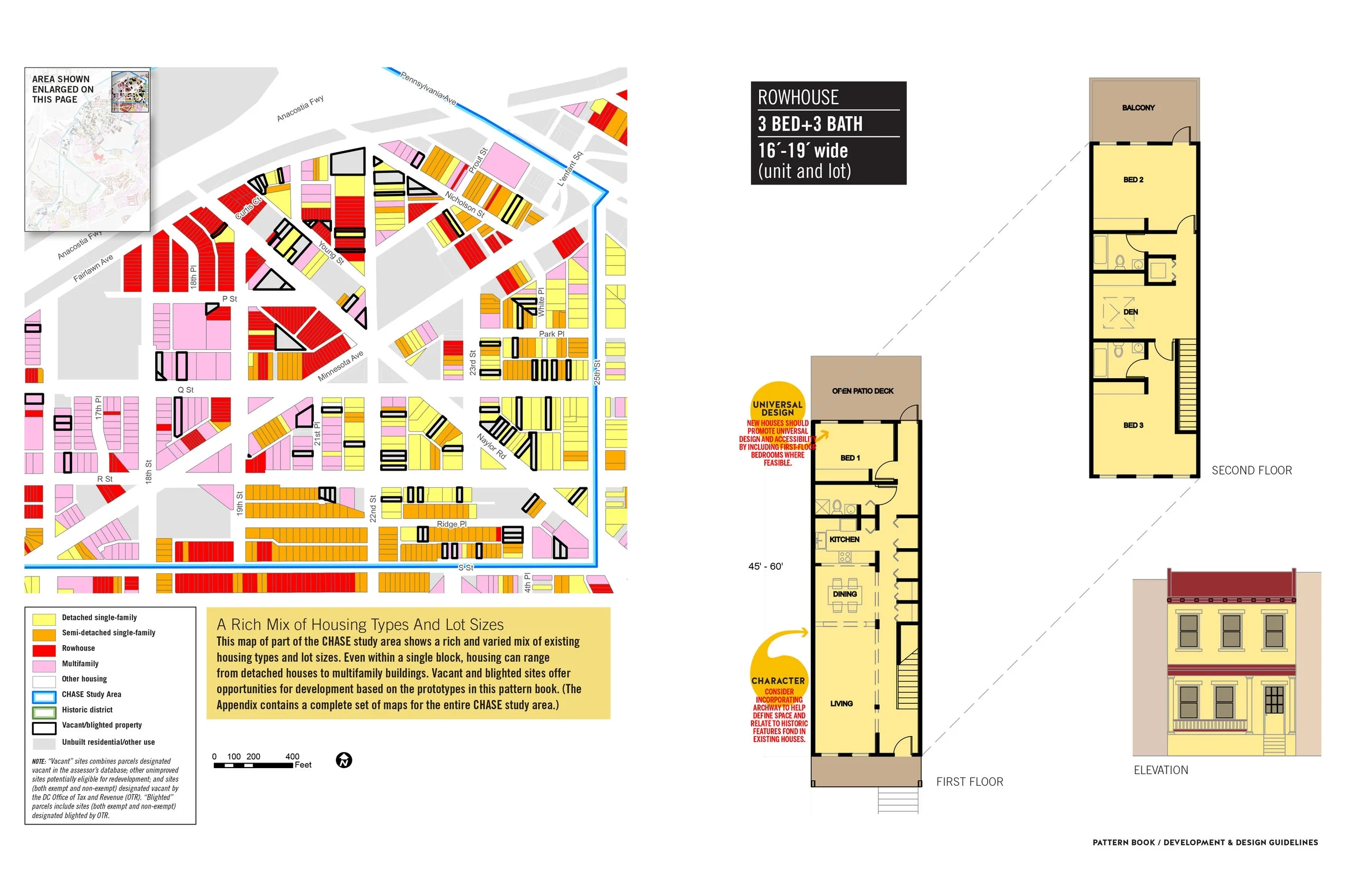
CHASE NEIGHBORHOOD PATTERN BOOK
District of Columbia Office of Planning
This Pattern Book represents one element of a larger effort by the District of Columbia Office of Planning to provide a strong basis for redevelopment within the Congress Heights, Anacostia, and Saint Elizabeths (CHASE) communities. The Pattern Book is based on buildings in the Anacostia Historic District, but it has broad applicability in all the CHASE neighborhoods. It conforms to local zoning, which sets out the legal requirements for development, and it provides additional design guidance to encourage infill that respects existing neighborhood fabric.
This document is intended primarily for developers planning to build infill housing on vacant lots, but it may also prove useful for homeowners interested in rehabilitating their homes.
Completed at: Goody Clancy
Project Role: Documentation of historic building types, analysis of existing inventory, development of contemporary plan alternatives, guidelines report
Completed at Goody Clancy, Boston, MA
Representing a transformative new chapter for the City of Somerville, the Inner Belt and Brickbottom plan serves as a strategic guide for developing this 150-acre area—one of two significant concentrations of redevelopable land close to Boston—into a lively, urban neighborhood. The Inner Belt and Brickbottom districts began as tidal marshes, evolved to support rail yards and heavy industry, and are now underutilized light industrial areas. By 2016 they will be served by MBTA Green Line light rail service, with a direct transit link to the heart of Boston.
Working closely with city leadership, residents, and local business and property owners, Goody Clancy’s interdisciplinary team developed a plan that incorporates:
Evolution of the Inner Belt/Brickbottom area into a vibrant city neighborhood—a walkable transit-served district of businesses, multifamily housing, and community park spaces
Economic positioning that identifies opportunities for development of office and research space, core elements of the city’s economic development strategy
Improved access to and through the area, now constrained by crisscrossing rail and elevated highway infrastructure
Framework for 6 to 10 million SF of new development created through practical, incremental steps that will result in a distinctive new sense of place for the district
Pedestrian-centered Housing Clusters/ Masdar City Detailed Master Plan: Phase 2
An emerging innovation hub outside of Abu Dhabi, Masdar City realizes a unique vision for a low-carbon, pedestrian-focused community in the midst of an auto-centric society.
Home to the Masdar Institute of Science and Technology, and a number of leading renewable energy groups, shops, restaurants, and residential communities, Masdar City is already redefining city building in the 21st century. The Phase 2 Masterplan focuses on R&D and Housing Clusters, commercial corridors, community centers, mosques, and schools. This diverse mix of landuses will be seamlessly connected by a continuous and a welcoming public realm comprised of walkable streets and a robust public transit network.
Completed at: CBT Architects
Project Role: Residential block and multi-family building type studies, parking analysis, visualization modeling, conceptual narratives.
YANGPU UNIVERSITY CITY SPECIFIC PLAN, Shanghai, China
The Yangpu district is the location of seventeen universities/ colleges and of more than two hundred research institutions amidst large tracks of dilapidated industrial areas, railway yards as well as an old airport waiting to be transformed. These educational and land resources create an opportunity for economic development and revitalization of a significant area within the Yangpu District.
The vision is to transform this area of separate universities into an integrated community of learning, working and living. The central area will be planned, designed and built to meet the needs of the ‘Knowledge Community’ consisting of university faculty, researchers, students, high-tech workers, investors, entrepreneurs, innovators and other professionals. Key components of the Yangpu University City include the Hub, the University Village, and Technology Parks along Songhu Road, the Stadium East Sports and Recreational Center and adjacent residential neighborhoods.
Completed at SOM San Francisco
Specific responsibilities: Infill studies, building type research and analysis, case studies.
O'DONNELL HEIGHTS MASTER PLAN, Baltimore, MD
Completed at: Goody Clancy
Client: Housing Authority of Baltimore
Specific Contributions: Project lead, community workshop facilitation, master planning and conceptual development, planning report and design visualization
CENTRAL ANNAPOLIS ROAD SECTOR PLAN, Prince George's County, MD
Annapolis Road is a 30-mile-long east-west arterial running from Annapolis through Prince George’s County to the outskirts of the District of Columbia. The sector plan focuses on a 1.77-mile, 250-acre segment of Annapolis Road with the goal of creating development and related zoning frameworks A major influence on the study’s process and recommendations has been a planned Light Rail Transit station – part of the new Purple Line connecting Bethesda to New Carrollton – to be located at the intersection of Annapolis Road and Veterans Parkway.
One of the key objectives of the planning process was to examine how the role of a state highway can be reconciled with the goals and aspirations of those for whom the surrounding areas constitute a real neighborhood. How do we transform a fleeting arterial into a memorable boulevard?
Completed at Goody Clancy Associates
Client: Maryland-National Capital Park and Planning Commission
Consultant Team: Goody Clancy, Robinson Associates, Kittleson & Associates, W-ZHA, Camiros, | Collaborators: Local residents and business owners, Maryland Transit Administration; the State Highway Administration; the Washington Metropolitan Area Transportation Authority;
Project Role: Site analysis, concept design, community workshop facilitation, consultant coordination, master planning report
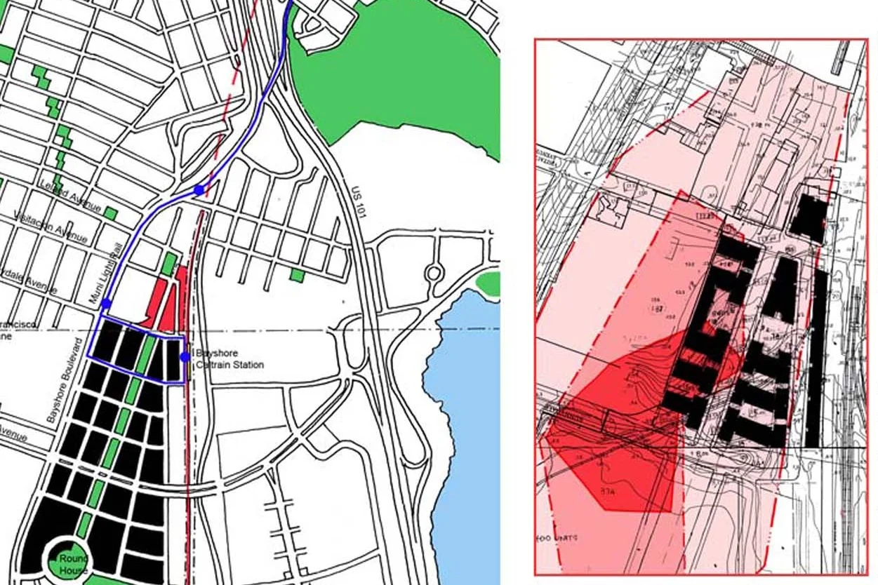
UPC TRANSIT ORIENTED DEVELOPMENT AND BROWNFIELD REMEDIATION
Located just north of the San Francisco / Brisbane city line, the project site is adjacent to the planned Bayshore inter-modal station that will combine CalTrain commuter rail and San Francisco Municipal Railway light rail services. The proposed development of approximately 450-500 unit residential neighborhood involves extensive on-site environmental remediation of the existing industrial parcels.
Completed at WRT|Solomon ETC
Specific Contributions: Project management, design development
Developers: Universal Paragon Corporation,
Renderings/ Axonometric Studies: Norman Kondy, John Ellis, Khushru Irani
BRIDGE STREET CORRIDOR STUDY City of Dublin, OH
The Bridge Street Corridor straddles Dublin's historical and cultural heart with walkable districts and neighborhoods on both sides of the Scioto River. The five vision principles articulate the action-oriented objectives that form a framework for decision-making, communicate the intent behind the plan's recommendations and provide a context for addressing critical issues and for guiding future development directions.
Vision Principles
1. Enhance economic vitality
2. Integrate the new center into community life
3. Embrace Dublin's natural setting and celebrate a commitment to environmental sustainability
4. Expand the range of choices available to Dublin and the region
5. Create places that embody Dublin's commitment to community
Completed at: Goody Clancy
Project Role: Site capacity & land-use studies, stakeholder interviews urban design diagrams and design visualization
Awards: Congress for the New Urbanism Charter Award, 2012 Honorable Mention
In 2011, two developers announced plans to redevelop 50-75 acres for 6 million SF in accordance with the plan and a new form-based code
New zoning regulations officially approved by the Dublin City Council in March 2012, acting as a blueprint for future development of the corridor
In 2013, Crawford Howing announced plans for a $300 million mixed-use development just north of Bridge Street, along the planned riverside park
DEVELOPERS TOOLKIT FOR THE I-95 REDEVELOPMENT COMMISSION
With 19 acres of readily developable land, The LINK provides the opportunity for a diverse and multitalented workforce, an established life sciences research cluster peppered with historic building bulidings, lively street life of Downcity, new signature parks and a walkable riverfront.
The toolkit illustrates a range of potential development opportunities through the 19 acres of The Link and explains how a typical project can move from concept to completion.
Completed at: Goody Clancy
Project Roles: Site analysis, development of urban design and planning concepts, site capacity study, building type and preliminary programmatic studies.
The handbook is a visual reference guide for residential site planning and preliminary capacity studies through a series of illustrated block-level building typology templates. It covers a range of densities and building types from 5 du/ac to 135 du/ac ranging from detached single family clusters to multi-family apartments with multi-level parking podium.
Completed at Planning Center (Placeworks) 2007
MAYFIELD MALL REDEVELOPMENT / Mountain View & Palo Alto, California
Redevelopment of 27 Acre Hewlett Packard office center site straddled across the towns of Mountain View and Palo Alto, with a new transit-oriented residential neighborhood adjacent to San Antonio ClTrain Station. The project comprises of approximately 550 for-sale owner-occupiedd housing units over a range of building types integrated with affordable housing units and public sites. The site plan reestablishes the connection between the development parcel and the existing historic neighborhood
Completed at WRT| Solomon ETC
Project Development: Toll Brothers Inc
Project Role: Project Management, Site planning and building type studies, regulatory studies
Renderings: Norman Kondy, John Ellis, Khushru Irani
CITY OF ALBANY DOWNTOWN PLAN & CORNING PRESERVE MASTER PLAN
The City of Albany and the Capitalize Albany Corporation initiated this market-driven process, with two parallel planning initatives
- a revitalization plan for the downtown district
- a master plan for its adjacent waterfront park.
The plans will establish the park as a downtown amenity, with strategies for overcoming a surface-level highway, which has historically hindered waterfront connections. The process has utilized a series of unique public engagement strategies, which have built early support for the process.
Major themes central to this planning process include:
- Celebrating downtown’s quality of life by highlighting its existing amenities
- Connecting downtown by reinforcing its walkable street network and establishing new connections across I-787 to the Corning Preserve waterfront park
- Empowering stakeholders to invest in downtown by facilitating initiatives built on public-private partnerships and produce shared benefits for all involved
Completed At: Goody Clancy Associates
Project Role: Visualization Studies, Diagramming and capacity studies
Awards: Downtown Achievement Award, 2016